23 September, 2023

ARAB ARABIA ARABAH


SAUDI ARABIA: the phrase "Saudi Arabia" was officially invented on 23 September AD 1932 by its founder, Abdulaziz bin Saud after founding the al-Mamlakah al-ʿArabīyah as-Saʿūdīyah (a transliteration of المملكة العربية السعودية in Arabic, of "the Saudi Arab kingdom"). The root word "as-Sa'udiyah" is derived from the "Al Saud" ("family of Saud"), whose ancestor was Saud ibn Muhammad ibn Muqrin, the father of Muhammad bin Saud (AD 1687–1765), the founder of the First Saudi State and Saudi Dynasty.
Needless to say, Saudi is not the biblical "Arabia."

The biblical "Arabia" is described by the Bible, as for an instance by the apostle Paul, to be located south or below Jerusalem, which means the biblical Arabia was near Jerusalem. Apostle Paul knew this because he lived 3 years in Arabia.

"Neither went I up to Jerusalem to them which were apostles before me; but I went into Arabia, and returned again unto Damascus. 
Then after 3 years I went up to Jerusalem to see Peter, and abode with him 15 days." -Galatians 1:17-18

Hagar, the Egyptian bondwoman of Sarah, lived in Arabia, particularly in the area of Makhtesh Ramon (Sinai) identified to be the land of Midian in Seir, making her grandchildren, from her son Ishmael, Midianites (Gen 21:14,21 & 37:28). 

"Which things are an allegory: for these are the two covenants; the one from the Mt. Sinai, which genders to bondage, which is Agar. 
For this Agar is Mt. Sinai in Arabia, and answers to Jerusalem which now is, and is in bondage with her children. But 

Jerusalem which is 

above 

is free, which is the mother of us all." -Galatians 4:24-26

In this allegory, Mt. Sinai in Arabia is in bondage, whereas Jerusalem above it is in freedom. Mt. Sinai as Hagar is mother of bondage, whereas Jerusalem is the mother of freedom.


In other cases, latter at the Babylonian Captivity, the term " מַעֲרָב " (maarab) is used in 1Chronicles 7:28, 12:16, 26:16,18,30 to mean "west," exactly to the direction of Arab in Negeb or south of Judah. 
But Joshua 8:9 uses that word "maarab" to mean "ambush" (Judges 9:35). A place with the name "Arab" is mentioned by Joshua to be located between Hebron and Beersheba. This is the first time that the word "Arab" was used as a toponym.


"Arab, and Dumah, and Eshean, And Janum, and Bethtappuah, and Aphekah, And Humtah, and Kirjatharba, which is Hebron, and Zior; nine cities with their villages" -Joshua 15:52-54

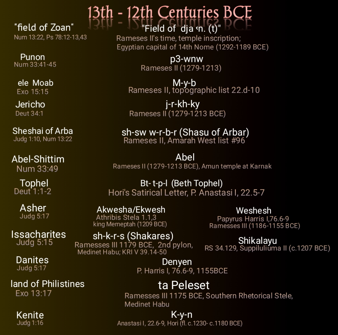
Arab in this passage is understood as "ambush." Although it is located south of Jerusalem and could be belonged to Seir (cf. Deut 1:44), but it was used as a descriptive for Kenite Midianites to mean "mixed people," whose ancestral territories were in Negeb, i.e. south of Judah. It was Moses who first used "Arab" to mean "mixed people" in their exodus in 1229 BCE which the Egyptians, particularly Ipuwer, called "desert people."

"And the children of Israel journeyed from Rameses to Succoth, about 600 elef strong foot-persons, beside children. And a 

רַ֖ב
[multitude]

עֵ֥רֶב
[‘êrebh/Arab]
mixed 

went up also with them; and flocks, and herds, even very much cattle." -Exodus 12:37-38
 
It is Moses also who revealed that the mixed people with them were the family of Kenite Jethro, priest of Midianites (Num 10:29-31, Judg 1:16). 
In 1Kings 10:15 the same term "'erebh" ("Arabh") is used for "Arabia" as indicated by its "kings" but can be also understood as "mixed countries."

"Beside that he had of the merchantmen, and of the traffick of the spice merchants, and of all the 

kings of Arabia, 

and of the governors of the land." -1Kings 10:15

Arabia referring to a place and not a people is a Hellenized form of "Arabah," an area near Negeb which during the reign of Jehoshaphat was referring to the east of the Philistine land (2Chronicles 17:11) near Kush (Makhtesh Ramon) in the south of Judah, hence both Philistines and Arabs were under the dominion of the king of Judah.

"Moreover YHWH stirred up against Jehoram the spirit of the Philistines

וְהָ֣עַרְבִ֔ים
[wə-hā-‘ar·ḇîm]
and of the Arabs


that were near the 

כּוּשִֽׁים
[Kushim]
Kushites

-2Chronicles 21:16

As being part of Judah's politics, the Philistines, Arabians, and Kushites [Makhtesh Ramon] from the south of Jerusalem killed the sons of Jehoram (Joram), save the youngest Jehoahaz. The same had happened when Arabs killed all Jehoahaz's sons except the youngest Ahaziah (Ochaziah) in 841 BCE.


"And the inhabitants of Jerusalem made Ahaziah his youngest son king in his stead: for the band of men that came with the Arabians to the camp had slain all the eldest. So Ahaziah the son of Jehoram king of Judah reigned." -2Chronicles 22:1

Arabs this time were distinct group of people to the east of Philistine land and Kush (Makhtesh Ramon) in the south of Judah (Jerusalem). 
Arabians were much concerned about the Jerusalem because they were affected if Jerusalemites were strong as they were obligated to pay tributes under its king.

"And the fear of YHWH fell upon all the kingdoms of the lands that were 

round about Judah, 

so that they made no war against Jehoshaphat. Also some of the Philistines brought Jehoshaphat presents, and tribute silver; and the 

Arabians 

brought him flocks, 7700 rams, and 7700 he-goats. And Jehoshaphat waxed great exceedingly; and he built in Judah castles, and cities of store." -2Chronicles 17:10-12

In this passage, Arabians were near Jerusalem the way Philistines were near to the capital city.
Arabians dwelt in Gur-Baal ('Ascend of Baal') near Maon (of Mehunim) and Philistine land.


"And he went forth and warred against the Philistines, and broke down the wall of Gath, and the wall of Jabneh, and the wall of Ashdod, and built cities about Ashdod, and among the Philistines. And God helped him against the Philistines, and against the 

Arabians that dwelt in Gurbaal, 

and the Mehunims. 

And the Ammonites gave gifts to Uzziah: and his name spread abroad even to the 

entering in of Egypt; 

for he strengthened himself exceedingly. Moreover Uzziah built towers in 

Jerusalem 

at the corner gate, and at the valley gate, and at the turning of the wall, and fortified them." -2Chronicles 26:6-9

Arab was near Philistine land and Maon (Tell Ma'in) of Mehunim.

"Arab, and Dumah, and Eshean, And Humtah, and Kirjatharba, which is Hebron, and Zior; nine cities with their villages: 

Maon, 

Carmel, and Ziph, and Juttah," -Joshua 15:52,54-55


Fortifying Jerusalem was a disgusting thing for the Arabians, Philistines (Ashdodites), and Ammonites of the border of Egypt.

"But it came to pass, that when Sanballat, and Tobiah, and the 

Arbim [Arabians], 

and the Ammonites, and the Ashdodites, heard that the walls of 

Jerusalem 

were made up, and that the breaches began to be stopped, then they were very wroth, 
And conspired all of them together to come and to fight against Jerusalem, and to hinder it." -Nehemiah 4:7-8

These "Ammoni" ("Ammonites") are probably distinguished from "Bene-Ammon" ("sons of Ammon") in 2Chronicles 20:1 as the latter are related and relatives of Bene-Mowab ("sons of Moab").

The name Arbayim (Arabians) is clarified by defining it "Arbim" ("Arabs") in 2Chronicles 26:7.


 "And God helped him against the Philistines, and against 

הערביים
[hā-‘Arḇîyîm]
the Arabians 

הָֽעַרְבִ֛ים
[hā-‘Arḇîm]
the Arabs

that dwelt in 


Gur-Baal [Ascend of Baal], and the Mehunims [Maonites]." -2Chronicles 26:7


It seems that the term "Arabiy" ("Arabians ") was used as a variant name for business traders of Midian during the time of prophet Isaiah hence when these business men saw opportunities in the desert west of Babylon, they transferred themselves bringing the name "Arabians" and "Midian" in the east. The Midianites, particularly Ishmaelites, had business trips to and fro in Gilead to Egypt as early as the time of Joseph (Gen 37:25,28). In Moses' exodus, Midian had senators in Moab (Num 22:4,7) for they were in confederation under the suzerainty of Sihon (Num 31:8, Josh 13:21). In Jerubaal's time, Midianites were in Ephraim (Judg 7:25 & 8:3). This gives us an idea that Midianites were scattering to all directions from Kushan (Makhtesh Ramon). In south of Judah they were known "Arbim" (Arabs), whereas in the eastern part of Jordan they were identified with the name Arabiy or Arabiyim (Arabians).

We have a high certainty that the word "Arabh" was derived from "'Erebh" as hinted by prophet Jeremiah.


"And all the kings of 

עֲרָ֑ב
[‘ă·rāḇ]
Arabia


and all the kings of 

הָעֶ֔רֶב
[hā-‘e·reḇ]
the mingled people 


that dwell in the desert" -Jeremiah 25:24


Just a century after Babylonian Captivity, the term "Arabian" was used as distant as to Wadi Tumilat of Egypt. Herodotus 2.158 reported that "Patoumos (Pithom was) a city in the Arabian nome." It was the 20th district of Northern Egypt and its capital was Goshen (Egyptian, "Ḳosen"). 

The masculine of Arabah used in Isaiah 21:13 and Ezekiel 27:21 is 


' rabh,


which literally means "desert plain," and translated into "Arabia." 

From 'arabh is derived the adjectival noun

ărāḇhî


in Jeremiah 3:2 understood as desert dwellers of south of Judah.

This similar 'Arabhi is referring to the desert dwellers near Babylon in the days of prophet Isaiah (13:19-20).

The Arabia in apostle Paul's epistle is referring to the Arabia Petrea, in the south of Judah to eastern in Jordan. The capital city was Petra, where Imru' al-Qays ibn 'Amr  received the title "King of all the Arabs" in the AD 328 Arabic inscription using Nabatean Aramaic alphabet. Arabs were widespread in the Egyptian peninsula from Petra to Wadi Tumilat in Egypt.
Roman emperor Hadrian (r. AD 117–138) had a map locating 

Arabes Nabataei 

in the desert regions, which were conquered by the Romans on March 22, AD 106 and renamed it Arabia Petraea and annexed as a Roman province. The Mafkat Peninsula became part of Arabia Petraea, a Roman province and now much known by the name Sinai Peninsula.

The Nabatean capital city was Raqmu ( 𐢛𐢚𐢒‎ or 𐢛𐢚𐢓𐢈‎,  rqm or rqmw,  *Raqēmō in Nabatean) which is Petra, taught to be derived from the name of its ancient ruler, Rekem. Josephus mentions that the Arabs in the first century were calling Petra as Rekeme after the name of its royal founder and describes it to be the "highest in the land of the Arabs" (Antiquities iv. 7, 1; 4, 7). 

One of the kings of Midian, namely Rekhem, managed to reign in Rekem during the time of Balaam son of Beor, whose hideout in Deir 'Alla was destroyed in circa 1189 BCE when Tausert was the pharaoh.

"And they warred against the Midianites, as YHWH commanded Moses; and they slew all the males. And they slew the kings of Midian, beside the rest of them that were slain; namely, Evi, and 

Rekem, 

and Zur, and Hur, and Reba, five kings of Midian: also Balaam ben-Beor they slew with the sword. And they burnt all their cities wherein they dwelt, and all their goodly castles, with fire." -Numbers 31:7-8,10

Rekem was a Midianite king allied to Moab under the rulership of Sihon.

 Lead by Phinehas, the grandson of Aaron, as the priest and Joshua as chief of staff of Moses, Israelites defeated the Moabite Midianites and even killed Rekem. 
As early as 1206 BCE, Shasu of Edom were used by king Merneptah as messengers and permitted to refresh their animals in Wadi Tumilat. This simply means that Edomites were an ally of the pharaoh and expected to be hostile against Israel. This also may explain why later Wadi Tumilat became an Arabian nome or the 20th district of the Northern Egypt as Midianites or Arabians of south Judah had amalgamated with or even had replaced Edomites.
The term Arabs or Arabians was not in used in the days of Joshua, but when these desert people was mentioned again, they were giving tributes to king Solomon, particularly the gold stationed in Ophir (Makhtesh Ramon) taken probably from Qurayya. This was in connection to the fact that the Kenite Midianites, under Moses' leadership with the Caphtorim (Philistine ancestors) afterwards under Joshua, dominated the Hejaz of Qurayya during the time of king Rameses II and Ramesses III by trading Atika to Hejaz. The troops of Moses, including Kenite Midianites, had transferred from Hormah (Tel Masos) to Edom (Timna Valley) and to Punon, hence Iron Age (1200 BCE) pottery bowls of Negev (south Judah) resembled Edomite and Philistine pottery in their decoration which also resembling Qurayya ware (aliased Midianite pottery). It was because of the gold, copper and business why Kenite Midianites under Israel became connected to Qurayya. 
This gives us insight why Arabs were obligated to pay tributes to king Solomon after David conquered many cities in Edom.

"Beside that which chapmen and merchants brought. And all the kings of 

Arabia 

and governors of the land brought gold and silver to Solomon. And he reigned over all the kings from the river even unto the land of the Philistines, and to the border of Egypt." -2Chronicles 9:14,26

In Eratosthenes' opinions Arabia Felix was lying in the southern of Coele-Syria, hence the ocean to its north was called "Atlantic sea" (Mediterranean ocean). When the term Arabia became extended in area, it was identified to be the length between Heroopolis to Nabataean Petra to Babylon. Thus, the biblical definition from Arab near Beersheba to Babylon was further stretched out by the Roman writers toward Wadi Tumilat, because the latter became the part of the 20th nome of northern Egypt corresponding to the Arabian nome. Before the 1st century, the term "Arabia" was designated to the region lying between the Nile and Red Sea (Aqaba Sea), as noted in Herodotus 2.8 and Strabo 17.1.34.
For this reason, the subcontinent between Delta (Egypt) and Petra became known Arabia, prominently when Mafkat Peninsula was included in Arabia Petraea in AD 106. With this incorporation, Jebel Musa - one of the Mafkat mountains -became more popular as Mountain of Moses. Inscriptions discovered there suggest that between 2nd and 3rd century, Nabataeans were the pilgrims of the region where Jabal Musa is belonged. Celebrity monks were residing in a church in one of the high mountains there that has cave, claiming that their residential area is site where Moses received the Ten Commandments - as on the foot of that mountain was a tree of bush (a monastery was probably built there by Elena, the mother of emperor Constantine). The mountain was so holy that none of the monks or priests who lived nearby were permitted to live on its summit. The inhabitants were identified Arabians and celebrating feasts for the moon, which may have also additional basis why the area was called Sina, whose etymology was "Sin," the ancient moon god, which in more ancient Egyptian rite was called "Yah," exactly homophonous to the Hebrew God's name "Yah."
  Egeria (Etheria), likely a Spanish nun, took a pilgrimage in Egypt to visit the Mountain of Moses. In around AD 383 she reached Jebel Musa. 

 “The mountains,” she writes in a diary, “are ascended with infinite toil” because they could not rise with donkeys but rather they had to “climb straight up the whole way, as if up a wall.” 
 

According to Antoninus Martyr (c.570 AD), Arabian heathens were still celebrating moon feasts on Jebel Musa. This practice was reduced or eliminated when the Byzantine emperor, Justinian I (AD 527-565), order the building of a monastery in the claimed Moses' burning bush site near Jabal Musa. Even Muhammad PBUH, the prophet of Islam, recognized it as the holy mountain, that he recited it in Qur'an 23:20, and identified Jebel Musa as Ṭūr Sīnā’ (Mt. Sinai). This gives us clue that the Arabia known to the 1st century and 7th century people, Christians or non-Christians, was what constituted to the subcontinent between Egypt proper and Nabatæan Petra. The entire subcontinent is now known Sinai Peninsula. Sinai during those two millennia was not known to be in Saudi but in Arabia of Sinai Peninsula.
This may give us hint that after apostle Paul, Sinai in Makhtesh Ramon was apparently, completely eaten by the earth there, leaving no trace of the mountain range, hence making Jews to find it in another location, that is, in Jebel Musa. The earliest inhabitants of the surrounding of Jebel Musa were Monitu, and their area was called Khetiu-Mafkat (ḫtiw-mfkꜣt, "Ladders of the Green Minerals") or ta mafkat (t3 mfk3.t, "land of turquoise") or Biau (bỉꜣw, "Mining Country").

The description that Arabia was between Nile and Nabatæan Petra was clear in some passages of Strabo.

"I return to the opinions of Eratosthenes, which he next delivers respecting Arabia. He is speaking of the 

northern 

and desert part, lying between Arabia Felix, Cœle-Syria, and Judæa, to the recess of the Arabian [Aqaba] Gulf.

From Heroopolis, situated in that recess of the Arabian [Suez] Gulf which is on the side of the Nile, to Babylon, towards Petra of the Nabatæi, are 5600 stadia. The whole tract lies in the direction of the summer solstice (i. e. east and west), and passes through the adjacent Arabian tribes, namely Nabatæi, Chaulotæi, and Agræi. Above these people is Arabia Felix, stretching out 12,000 stadia towards the south to the Atlantic Sea.

The first people, next after the Syrians and Jews, who occupy this country are husbandmen. These people are succeeded by a barren and sandy tract, producing a few palms, the acanthus, and tamarisk; water is obtained by digging [wells] as in Gedrosia. It is inhabited by Arabian Scenitæ, who breed camels. 
...
Merchants arrive in seventy days at Minæa from Ælana. Ælana [Aileı́m] is a city on the other recess of the Arabian Gulf, which is called 

Ælanites, opposite to Gaza,...


...

After the bay is the island Ophiodes, so called from the accidental circumstance [of its having once been infested with serpents]. It was cleared of the serpents by the king, on account of the destruction occasioned by those noxious animals to the persons who frequented the island, and on account of the topazes found there. The topaz is a transparent stone, sparkling with a golden lustre, which however is not easy to be distinguished in the day-time, on account of the brightness of the surrounding light, but at night the stones are visible to those who collect them. The collectors place a vessel over the spot [where the topazes are seen] as a mark, and dig them up in the day. A body of men was appointed and maintained by the kings of Egypt to guard the place where these stones were found, and to superintend the collection of them.

...

Next is the island of Phocæ (Seals), which has its name from those animals, which abound there. Near it is a promontory, which extends towards Petra, of the Arabians called Nabatæi, and to the country of Palestine, to this [island] the Minæi, Gerrhæi, and all the neighbouring nations repair with loads of aromatics.


Next is the Ælanitic Gulf and Nabatæa, a country well peopled, and abounding in cattle. 

... 
Near these people is a nation more civilized, who inhabit a district with a more temperate climate ; for it is well watered, and has frequent showers. Fossil gold is found there, not in the form of dust, but in lumps, which do not require much purification. The least pieces are of the size of a nut, the middle size of a medlar, the largest of a walnut. These are pierced and arranged alternately with transparent stones strung on threads and formed into collars. They are worn round the neck and wrists. They sell the gold to their neighbours at a cheap rate, exchanging it for three times the quantity of brass, and double the quantity of iron, through ignorance of the mode of working the gold, and the scarcity of the commodities received in exchange, which are more necessary for the purposes of life. 


...

The Nabatæans and Sabæans, situated above Syria, are the first people who occupy Arabia Felix. They were frequently in the habit of overrunning this country before the Romans became masters of it, but at present both they and the Syrians are subject to the Romans.

The capital of the Nabatæans is called Petra. It is situated on a spot which is surrounded and fortified by a smooth and level rock (petra), which externally is abrupt and precipitous, but within there are abundant springs of water both for domestic purposes and for watering gardens. Beyond the enclosure the country is for the most part a desert, particularly towards Judæa. Through this is the shortest road to Jericho, a journey of three or four days, and five days to the Phœnicon (or palm plantation). It is always governed by a king of the royal race. The king has a minister who is one of the Companions, and is called Brother. It has excellent laws for the administration of public affairs.

...
...

Merchandise is conveyed from Leuce-Come to Petra, thence to Rhinocolura in Phœnicia, near Egypt, and thence to other nations. But at present the greater part is transported by the Nile to Alexandreia. It is brought down from Arabia and India to Myus Hormus, it is then conveyed on camels to Coptus of the Thebais, situated on a canal of the Nile, and to Alexandreia. 
..." -Strabo 16.4

08 September, 2023

EXODUS' TOPONYMS


Moses mentioned a lot of geographical names or toponyms and instances from the 13th-12th centuries BCE Egyptian timeline. Direct and indirect pieces of evidence of his reports, historical materials, and circumstances bracket the date of Israelite exodus to the 13th century BCE.
In his following report we can get many details that no other copies of the 14th or 15th century BCE can be ascribed as their circumstances:


Numbers 33:2-44

"And Moses wrote their exodus according to their journeys by the commandment of YHWH: and these are their journeys according to their goings out: They left 

Rameses 

on the 15th day of the 1st month; on the day after the passover the children of Israel went out with an high hand in the sight of all the Egyptians. For the Egyptians buried all their 

firstborn, 

which YHWH had smitten among them: upon their 

gods 

also YHWH executed judgments. 
And the children of Israel removed from Rameses, and camped at 

Succoth

And they left Succoth, and camped at Etham, which is in the edge of the wilderness. 
And they left Etham, and turned again unto Pihahiroth, on front of

Baalzephon

and they camped on front of Migdol. From the front of Pihahiroth they moved, and passed through the midst of the 

yam [sea] 

into the wilderness, and went 3 days' journey in the 

wilderness of Etham

and camped at Marah, and then came unto Elim: and in Elim were 12 fountains of water, and 70 palm trees; and they camped there. 
And they left Elim, and encamped by a sea of reeds. Then they moved from a sea of reeds, and encamped in the 

wilderness of Sin

And they took their journey out of the wilderness of Sin, and encamped in Dophkah, and then encamped in Alush, and then from there they encamped at 

Rephidim

where was no water for the people to drink. And they left Rephidim, and camped at the 

wilderness of Sinai

And they removed from the desert of Sinai, and camped at Kibrothhattaavah, and then encamped at 

Hazeroth

And they left Hazeroth, and pitched in Rithmah. They left Rithmah, and pitched at Rimmon-parez. And they departed from Rimmon-parez, and camped at Libnah, then they left Libnah, and pitched at Rissah. And they journeyed from Rissah, and pitched in Kehelathah. They went from Kehelathah, and pitched in Mt. Shapher [Tophel?]. And they removed from Mt. Shapher, and encamped in Haradah. They left Haradah, and pitched in Makheloth. And they removed from Makheloth, and encamped at Tahath
They left Tahath, and pitched at Tarah. They removed from Tarah, and  camped at 

Mithcah. 

And they went from Mithcah, and pitched in Hashmonah [Azmon?]. They left Hashmonah, and encamped at Moseroth. They departed from Moseroth [Moserah "Bond"], and pitched in Benejaakan  [sons of Jaacan], and then encamped at Hor-ha-gidgad
And they went from Hor-hagidgad, and camped at Jotbathah. They left Jotbathah, and encamped at Abronah. They departed from Ebronah [Passage], and encamped at Eziongaber. And they removed from Eziongaber, and camped at the 

wilderness of Zin, which is Kadesh. 

They left Kadesh, and pitched in Mt. Hor, in the 

edge of the land of Edom.
 
And Aaron the priest went up into Mt. Hor at the commandment of YHWH, and died there, in the 40th year after the children of Israel were come out of the land of Egypt, in the 1st day of the 5th month. 
And Aaron was 123 years old when he died in Mt. Hor. 
And the Canaanite king of Arad, who dwelt in the Negeb in the land of Canaan, heard of the coming of the children of Israel. 
They left Mt. Hor, and pitched in Zalmonah. And they departed from Zalmonah, and pitched in Punon, and then camped at Oboth. They left Oboth, and pitched in Iye-abarim, in the border of Moab." -Numbers 33:2-44


WRITING OF THE AGENT OF Yahweh

The first part of the passage above claims that an agent of YHWH, in this case "Moses," wrote about their exodus under the command of that God. 
The earliest document that provides evidence that an agent of God Yahweh wrote an order related to that God and His people is in the Curse Tablet discovered from the Mt. Ebal's Joshua's altar dated between 1400 and 1200 BCE.


 Take note that it is not dated between 1500 and 1400 BCE.


MIGDOL


The description for Migdol's location here fits what Migdol of Seti was all about which was published in around 1280s BCE in the inscription now known Papyrus Anastasi V 19.2-20.6: it is located to the east of the palace (Pi-Rameses); in addition to this, the Papyrus Anastasi III 2:8-3:3 has Pihahiroth located in Rameses city, whereas Baalzephon to be near Pi-Rameses and Migdol. 

Baalzephon was one of the known places under Egypt in the reign of Rameses II, and which was published around 1225 BCE in the Papyrus Sallier IV 1:16 with the toponym

" b'r dj3pn" ("Baar djepon"),

which could the toponym 

 "Baal- ..." 

in the Papyrus Anastasi III 2:8 - geographically within the sphere of Rameses, Pihahiroth and yam Tuffy in the same passage in 3:3 innumerated around 1211 BCE by a scribe of king Merneptah (Nephtoah). This latter inscription has confirmed Moses' report.

Pihahiroth is the Hebrized rendition for the 1211 BCE Egyptian word 

"pr hwt hrt"

derived from the root word 

הַֽחִירֹ֔ת
"Hahiroth"

mentioned in Numbers 33:8, which was originally from the Egyptian 

"hwt w'rt,"

Grecized into "Auaris" (romanized "Ávaris").

 It was king Amenemhet I (1991-1962 BCE) who founded that "Hwt w'rt" (Avaris), which afterwards became part of the 19th nome.

 During Moses' days, a less significant part of it was renamed "Pi-Hahiroth," the exact date of which is 1211 BCE.

In Papyrus Anastasi III 2:8-3:3, Pihahiroth is described to be in or near the Rameses city.


PAPYRUS ANASTASI III

 Containing didactic excerpts and hymns, and by Armenian merchant Giovanni Anastasi it has reached the British Museum in 1839 (number 10246, 3).

 It locates
Baal-Zephon,
Yam Suph (Reeds' Sea), 
"Rameses," and 
"Pihahiroth

in the eastern Delta. This is one of the hardest evidence that biblical Moses is accurate and lived during the time of those toponyms.
 Why? 
Because there is no another document before or after 1211 BCE that has named simultaneously those four name places. Moses confirms the report of Papyrus Anastasi III 2:8-3:3, and vice versa.

The Papyrus Anastasi III inscription is telling Egyptians about...


"the waters of Baal... 
P3-twfy 
(the Tufy) 
comes to papyrus reeds and p3-h-r (the Horus) to rushes. Twigs of the orchards & wreaths of the vineyards [visited by] birds from the Cataract region. It leans upon [the shore of]
 
p3 yam 
[the Sea]

with begi-fish and buri-fish, and even their hinterlands provide it. The Great-of-Victories youths are in festive attire every day; sweet moringa-oil is upon their heads having hair freshly braided. They stand beside their doors. Their hands bowed down with foliage and greenery of

pr-hwt-hrt 
(Pi-Hahirot)

and flax of the Waters-of-Horus. The day that one enters
 
Rameses
wsr-m3'-r' stp-n-r'

L.p.h. ..." - Papyrus Anastasi III, 2:8 -3:3

In this papyrus is mentioned an area called 

"Rameses."
 
It is described here that 
Baal (to the north),
 Pi-Hahirot, and
 Yam Tufy 
were areas located in or just near the area of "Rameses."
The inscription clearly tells us that the said "Rameses" is derived from the name of king Rameses the Great (1279-1213 BCE) as it is mentioning the regnal name " wsr-m3'-r' stp-n-r' " (Usermaatre Setepenre). It also suggests that the name "Tufy" (borrowed by Moses as "suph" or "Suf ") is derived from the word papyrus reeds. This Tufy (Suph) was located near "P3 yam" (which Moses in Numbers 33:8 called "ha yam," meaning "the sea"), which is facing Baalzephon, Pihahiroth and Migdol.
Papyrus Sallier IV, 1:16, written around 1225 BCE, likely identified the toponym "Baal-" here to be 

"b'r  dj3pn"
("Baal-Zephon').

This gives the exact timeframe from what years did Egyptians use the toponyms 

"Baal-zephon,"
"Rameses,"
"Pi-Hahirot,"
and 
"Yam Suf "

and that is between around 1225 and 1200 BCE. 
The most important: this inscription proves that Moses is right in his report that there were toponyms
"Baal-zephon," "Rameses," "Pihahiroth," and "Yam Suf" (Reeds' Sea) during exodus of Israel -which means exodus happened during the days of king Rameses II (1229 BCE). 
Modern feeling-based thinkers discredited this accuracy and like atheists they claim that these toponyms are an anachronism. The basis of this feeling is that Genesis  47:11 mentions too the toponym "Rameses," inclined to the preconceived belief that Moses was not the writer of the original edition of the book of Genesis. Another basis is the belief that Moses does not give the exodus timeframe and therefore the calculation of not-eyewitnes writer must be the source of accurate timeline, even though that writer was more than six hundred years distant from Moses or the exodus.
Nonetheless, Moses and contemporary Egyptian inscriptions are more reliable than any latter feeling-based opinion. If we will use Papyrus Sallier IV as an exodus-date determination, exodus would have happened before 1225 BCE during the time of king Rameses II. 
And yes, according to Moses, the firstborn son of Rameses city died and it resulted to the expulsion of the Hebrews from Rameses. Moses has reported too that this death had affected the Egyptian gods, and the most affected was but Rameses II himself, who that time was functioning as an Egyptian god. All these pieces of information give us a sharp point that the crown prince, who was sitting on the pharaoh's throne, died when the pharaoh (Rameses II) was legally an Egyptian god before 1225 BCE, was no other than but prince Ramesses B junior, who died in 1229 BCE during the Year 50 of king Rameses II the Great. Moses is accurate in his claim that the crown prince was a "firstborn son" and "sitting on the throne of the pharaoh.
For a crown prince to sit on the throne of his father, his father must have served more than 30 years as pharaoh and must have legally, ritually functioning as an Egyptian god. It was a legal tradition in Egypt that a pharaoh would celebrate his first heb sed (jubilee festival) in his regnal Year 30, and every 3rd year after that. The pharaoh would ritually transform into an Egyptian god of the state in his heb sed festival. The pharaoh during exodus was more than 30 years on throne and ardently functioning his obligation as an Egyptian god, giving him permit to let his crown prince sit on his throne and function as a king of Egypt in his behalf. According to Moses, this crown prince was firstborn son. And yes, prince Ramesses B junior was the firstborn son of Rameses II to Queen Isetnoftet and was made crown prince in 1255 BCE after the unexpected death of the eldest son Amunherkhepeshef and mother Nefertari.
As what we have learned from Anastasi III, there was an every day feast of youths in Pihahiroth, which was in Rameses city. Pihahiroth could not be far from Rameses city as indicated in the following inscription written in circa 1211 BCE:

Festivities of youths were in Pihahiroth in Rameses city.

"The Great-of-Victories youths are in festive attire every day... They stand beside their doors. Their hands bowed down with foliage & greenery of

pr-hwt-hrt 
(Pi-Hahirot) ...

The day that one enters
 
Rameses
wsr-m3'-r' stp-n-r'

l.p.h. ..."  -Anastasi III, 3:3


And this description is accurate because the original Avaris (Hwt w'rt) was 2 kilometers distant from Pi-Rameses and under the ground. There was a day that king entered Rameses city while youths were waiting at their doors with foliage of 

pr hwt hrt 
(Pi-Hahiroth).

 But this turned into a great mourning when the crown prince died in 1229 BCE. This could be the incident that caused Rameses II to be silent about the untoward activities of the troops of Yar-su (Moses), as complained by Ramesses III. The royal scribe of the time has described it this way:


"Behold, things have been done which have not happened for a long time past; the king has been deposed by the rabble." - Admonitions of Ipuwer, VII


Such this incident that took place in 1229 BCE is a confirmation of what Moses has already warned of the Hebrews that ...


"Every firstborn in the land of Egypt shall die, from the firstborn of Pharaoh sitting upon his throne, even unto the firstborn of the maidservant that is behind the mill; and all the firstborn of animals
And there shall be a great cry throughout all the land of Egypt, such as there 

was none like it before,

nor shall be like it any more." -Exodus 11:5-6


And yes, not a single firstborn son of Rameses succeeded on the throne because all his firstborn sons died earlier than him. It was his 13th son, prince Merneptah, who successfully succeeded him. This proves that Moses is accurate in the details of his report. Joshua named Merneptah (Nephtoah) by a water supply in the forest of city of Jearim (Josh 15:9 & 18:15).
King Rameses II (1279-1213 BCE) built the largest tomb (KV 5) in the Valley of the Kings in Egypt and he buried there his firstborn son, crown prince Ramesses B junior and all of his children who died before he died. 
That the crown prince was functioning as "king of Egypt" is hinted in the report that he warned Moses of death if the latter would see his face again.


"And Pharaoh said unto him, Get thee from me, take heed to thyself, 

see my face no more;

for in that day thou seest my face thou shalt die. 
And Moses said, Thou hast spoken well, I will see thy face again no more." -Exodus 10:28-29


Why Moses could not see him again?

 
"And all the firstborn in the land of Egypt shall die, from the firstborn of Pharaoh that sits upon his throne,..." - Exodus 11:5


It was prophesied. Moses already knew that he would not see again that guy sitting on the pharaoh's throne, because that firstborn son (acting as "pharaoh ") would have died in April of 1229 BCE. 
On contrary, Moses saw again the real pharaoh (the father of the guy who sat on the throne). Again, Moses is proved correct in this minute detail: that the firstborn son was sitting on the throne acting as pharaoh, who warned him not seeing his face again. It was the real pharaoh who summoned Moses and asked and permitted to go in the wilderness as the citizens were afraid of the possible calamities that might have annihilated them by not allowing Hebrews to go to the Land of Yahweh in the wilderness.


"And it came to pass, that at midnight YHWH smote all the firstborn in the land of Egypt, from the firstborn of Pharaoh that sat on his throne unto the firstborn of the captive that was in the dungeon; and all the firstborn of cattle. 
And Pharaoh rose up in the night, he, and all his servants, and all the Egyptians; and there was a great cry in Egypt; for there was not a house where there was not one dead. And he called for Moses and Aaron by night, and said, 
'Rise up, and get you forth from among my people, both ye and the children of Israel; and go, serve YHWH, as ye have said. Also take your flocks and your herds, as ye have said, and be gone; and bless me also.' 
And the Egyptians were urgent upon the people, that they might send them out of the land in haste; for they said, 'We be all dead men.' 
And the children of Israel journeyed from Rameses to Succoth, about 600 elef strong foot-persons, beside the little ones. And a mixed multitude went up also with them; and flocks, and herds, even very much cattle." -Exodus 12:29-33,37-38


There were 598 elef (or around 600 eleph) in the capital city, and their escape as described in Exodus was permitted by the pharaoh and Egyptians. They went to Succoth, most likely to gather other Hebrews.
An intriguing part of the report is that 

"Also 

עֵ֥רֶב
(Arab/Ereb)

רַ֖ב
(rabh)
 
went up too with them..." - Exodus 12:38


Using the understanding of the word "rabisu" during Akhenaten's days, "rabh" here may mean "general" or officer, whereas "Ereb" translated as "mixed" is understood in 1Kings 10:15 as "Arab" or mixed people. The known mixed people with them were the Kenite Midianites: some traces of Philistine names might have indicated that some of them were relatives of the Philistine (1Sam 15:6, Judg 4:11, Num 10:29-33, Judg 1:16).

Why Hebrews' next station was Succoth?


King Rameses II when erected a stela for Moses on front of the palace in Pi-Rameses stated that "Moses is the beloved of Atum," giving insight that the patron source of Moses is Atum. This Atum could be a deified version of Assyrian "Adamu," known in Babylonian as "Amutu" and in Hebrew as "Adam," who was created from earth - or as Egyptian teaching has had, Atum was created in mound from waters by himself. 
The center or hub of this god Atum was built by Rameses II in Tell el-Retabeh known with the city name "Pr-itm," pronounced by Moses as "Pithom." Some outdated atheists think that Rameses built this Pithom in 7th century BCE, but scientific findings proved that it was built in the 13th century BCE. 
The inhabitants of Pithom were not necessarily Egyptians but people who probably claimed had descended from Atum (Amutu, Adamu, Adam). In archaeological findings, these people were descendants of Hyksos from Syria, corroborating Moses' claim that Hebrews' patriarch came from Aram or Syria (Deut 26:5).
He has also claimed that the Hebrews were tasked to 

"... built for Pharaoh store-cities, Pithom and Raamses." -Exodus 1:11


 Amenmonē verified that the workers of king Rameses II in Delta in building temple or palace in Pi-Rameses were the 'Apiru, also known Habiru (Hebrews).


HABIRU WORKERS

Simultaneous building projects of Rameses II (1279-1213 BCE) required a lot of workers from north to south. Amenmonē was reminded to 


"Give food rations to the soldiers and the Apiru-laborers who are drawing water from the well of Pre of Rameses II, L.p.h., south of Ai-gy-ptos

(Leiden Papyrus 349), and 


"Give food rations to the people of the army and to the 'Apiru who are dragging stones for the great pylon [temple gate of Rameses the Great]" (Leiden Papyrus 348).


That Apiru or Habiru were involved in building the projects of king Rameses the Great in Delta is a historical fact. They erected the gate of the temple of the palace of Rameses II in Pi-Rameses, and they could be also the Semitic workers who built Pithom in Tell el-Retabeh in the 13th century BCE.
 According to Inena, scribe of Merneptah in 1206 BCE, Etham and Pithom were in Succoth, where Succoth is what we know today Wadi Tumilat (Papyrus Anastasi 6.51-61). And scientists confirmed that Pithom of king Rameses II was in Wadi Tumilat, specifically in Tell el-Retabeh, in which the Semitic workers constructed 18 feet (6 meters) thick mud-brick defense wall, garrison barracks and granaries. This Pithom was abandoned around 1229 BCE, most likely after Moses entered it after their escape from Rameses.

In this case, Moses is referring to the 13th century BCE Rameses, Pithom, Succoth, and Etham. 


ETHAM MEANS SHUR


Etham could be a corruption of the Egyptian word "khetam," meaning "wall," which Moses has translated into "Shur" ("wall"). The geographical position of this Etham, according to Moses, is in the edge of the wilderness (Num 33:6, Exo 13:20). Wilderness is in the east, and is also called wilderness of Shur (Etham).


"And they departed from before Pihahiroth, and passed through the midst of the sea into the wilderness, and went 3 days' journey in the 


wilderness of Etham, 

and camped at Marah." -Numbers 33:8


"So Moses brought Israel from the Reeds'  Sea, and they went out into the 

wilderness of Shur; 

and they went 3 days in the wilderness, and found no water." -Exodus 15:22
 

Shur is to the south of Kadesh and Gerar or south of Havilah (where the Amalekites lived to the way going to Assurah). 
This Shur is opposite and "near Egypt" (Gen 20:1 & 25:18; 1Sam 15:7 & 27:8 ). 

West of this Shur (Etham) is the wilderness of Reeds' Sea and the way of Reeds' Sea. The way to Shur was called "way of the Reeds' Sea," which is south of the "way to Gerar (the land of the Philistines)." This way is heading toward the territories of the Amalekites in Havilah, Negeb, Kadesh, and Tamar (Exo 13:17-18, Num 14:25). Needless to say, Reeds' Sea (yam suph) is in the west of Etham just on front of Pihahiroth (House of Avaris), whereas the wilderness is in the east.

"And they left Etham, and turned again unto Pihahiroth, which is on front of Baalzephon: and they camped on front of Migdol. And they departed from before Pihahiroth, and passed through the 

midst of the sea 

into the wilderness, and went 3 days' journey in the wilderness of Etham, and encamped at Marah." -Numbers 33:7-8

The water there was probably stagnant, making it an untasteful to drink. 

"And when they came to Marah, they could not drink of the waters of Marah, for they were bitter: therefore the name of it was called Marah." -Exodus 15:23

After asking YHWH, Moses saw a tree and he cast it into the water, which may have turned open and flown the water, giving now a fresh water. 

TAMAR - THE LAND OF PALM TREES
Symbol of Judah's military activity


From Marah they went to Tamar, the land of palm trees, specifically in Elim, where there are many rivers or streams of water. From there they moved to reeds' sea (either another body of water with reeds or a body of water in the way of the Reeds' Sea). Then they went in the wilderness of Sin. 
Sin is singular form of "Sinai." 
From that wilderness they went to Dophka, then to Alush, and then in Mt. Horeb in Rephidim in the area belonged to Kadesh (Exo 17:1-8). 


"... the Negeb country, and dwelled between Kadesh and Shur, and sojourned in Gerar." -Genesis 20:1
 
Gerar was the "land of Philistines," and probably even king Ramesses III (1186-1155 BCE) recognized it as such, and it could be reached by the "way of the land of the Philistines," whereas Kadesh was an inhabiting place of the Amalekites and could be reached by the "way of the Reeds' Sea" passing through the wilderness of Shur (Exo 13:17-18). A particular area of this Kadesh is the station of Miriam and known "Kadesh-barneah" (the name of which signifies exodus, for it means "Holy Ground of the Wandering in Desert"). One of its sites is the wilderness of Zin, in which belonged the Rephidim, where Mt. Horeb was located. According to Moses, Kadesh is in the border of Edom - to the north of west, and he reiterated it by saying that Mt. Hor was in the edge of the land of Edom (Num 29:14,16).


"And they removed from Kadesh, and camped at Mt. Hor, in the edge of the 

land 

of Edom." -Numbers 33:37

The term "eretz" ("land") in this specific passage was an Hebrew translation of the Egyptian hieroglyph "khasut" (depicted as "mountain," but translated as "foreign land"). The edge of mountains here is what we can see as fence of mountains that signifies as the boundary of Edom ("gebul," border, in Num 20:23). One of the possible mounts in that mountainous fence was  Hor-hagidgad, which could be part of the mountains of Moseroth, which probably retains its name to the now Jebel Madeirah, just north of Makhtesh Ramon. Hor-ha-Gidgad could be composed of Mt. Hor and Gudgodah (Deut 10:7).

The root word of Hor-ha-Gidgad and Hor-mah could be what the Egyptians knew as "Khor" (Kharu), whose region is known in the Merneptah Stele as near the site of tribe Israel in 1208 BCE. Horim (Horites), from whom Seir came, were what the Egyptians identified "Kharu." 
The name Mount Horeb, if does not mean "volcanic" or "volcano," could be also derived from "Khor." Needless to say, Kharu were earlier inhabitants of Mt. Horeb, Hor-ha-Gidgad, Mt. Hor, and probably Hormah. In fact, Moses has been describing Hormah to be belonged to Seir (Deut 1:44). In the Bible, Kharu is Horim (Horites) living in Seir. 

MT. HOREB IN REPHIDIM IN KADESH, SOUTH OF ARAD

The incident of hitting a rock, to gush out water, took place in Mt. Horeb at the specific area called Meribah, in Kadesh in the wilderness of Zin near Tamar south of Arad.

"For ye rebelled against my commandment in the desert of Zin, in the strife of the congregation, to sanctify Me at the water before their eyes: that is the water of Meribah in Kadesh in the wilderness of Zin." -Numbers 27:14


"... at the Negeb side toward Teman, the border shall be even from Tamar unto the waters of Meribat-Kadesh, and to the river upon the [Mediterranean] great sea." -Ezekiel 48:28

"Because ye trespassed against me among the children of Israel at the waters of Meribah-Kadesh, in the wilderness of Zin; because ye sanctified me not in the midst of the children of Israel." -Deuteronomy 32:51

At first, on circa May 29, 1229 BCE from the wilderness of Sin, it was the older Hebrews who committed sin at Horeb in Rephidim, hence the exact site was called Massah or "Testing" (Exo 16:1 & 17:1-8, Deut 6:16). At the latter part of the Late Bronze Age Collapse, famine caused by drought became severe that the famous Massah spring ceased to give water again. The next time they went in that place, in 1190 BCE, it was Moses who committed sin because he hit the rock instead to speak on it and praise YHWH to let water gush out, the reason of which why Moses in 1189 BCE was not permitted to enter the Promised Land (Ps 106:32). The site is called Meribah ("Quarrelling") located in Kadesh-barneah (Num 20:1-13, cf. Deut 9:22-23), and since Moses' last year till to the king David's song writer and to prophet Ezekiel, Meribah remains flowing with water (Num 20:13, Deut 33:8, Ps 81:7, Ezek 47:19).

 What this tells us all about? It only assures us that Horeb in Rephidim was located in district of Kadesh-barneah in the part of the wilderness of Zin near Tamar (area of Palm Trees) or central Negeb south of Arad.
Learning that Israel was heading toward the Kenite area, the Amalekites ambushed the hindmost of the Hebrews in Rephidim when they were entering the border of Egypt and Edom in Kadesh-barneah to the wilderness of Sinai, understandably because Kadesh was an Amalekite territory (Exo 17:7-8, Deut 25:17-18, cf. Gen 14:7). It was this Amalek why Moses was ordered and inspired to write a book, most likely the "Wars of YHWH" (Exo 17:14,16, Num 21:14).

"Thus says YHWH of hosts, I remember that which Amalek did to Israel, how he ambushed him on the way when he came up from Egypt." -1Samuel 15:2


 The troop of 12 spies has positively identified Amalekites as the inhabitants of Negeb and of the valley in the way of the Reeds' Sea (Num 14:25).

"The Amalekites dwell in the land of Negeb..." -Numbers 13:29


"Behold, I will stand before you there upon the 

rock in Horeb; 

and you shall 

smite the rock, 

and there shall come water out of it, that the people may drink. And Moses did so in the sight of the elders of Israel. 
And he called the name of the place 

Massah, and Meribah, 

because of the chiding of the children of Israel, and because they tempted YHWH, saying, Is YHWH among us, or not? 
Then came Amalek, and fought with Israel in Rephidim. 
And Moses said unto Joshua, Choose us out men, and go out, fight with Amalek: tomorrow I will stand on the top of the hill with the rod of God in mine hand. 
And Joshua discomfited Amalek and his people with the edge of the sword. 
And YHWH said unto Moses, Write this for a memorial in a book, and rehearse it in the ears of Joshua: for I will utterly put out the remembrance of Amalek from under heaven. And Moses built an altar, and called the name of it Yahwe-nissi" -Exodus 17:6-9,13-15

MOSEROTH : MORE THAN ONE MOSERAH

There were more than one Moserah: one was where Mt. Hor or Hor-Gudgodah (Slashing/Happy Mount) is likely located. The other one was the camping site of the children of Levites after passing the wells of the sons of Jaacan. The other troops followed in Bene-Jaakan after staying at Moserah. It was in their time in Jotbathah when Levites were separated to bear the Ark of the Covenant and became focused on ritual activities (Deut 10:6-8). There were troops that went from Abronah to Eziongaber and walked back to wilderness of Zin to meet Miriam's troops perhaps to give respect to the death of Miriam (d. March 31, 1190 BCE), and all of them met in Mt. Hor. This mount is in the edge of Edom in Negeb, south of Arad.

The account in Deuteronomy 10:6-8 suggests that the narrator was present when Aaron died in one of the mountains of Moseroth and it was the Levites who were with Moses, whereas the account in Numbers 33:31-41 suggests that the narrator is telling about the presence of Hebrews when Aaron died (that they deviated from Moseroth going to Bene-jaakan to Hor-hagidgad then to Jotbathah and then to Passage or Abronah going to Ezion-geber, but were forced to go back to Moseroth, specifically to Kadesh when Miriam died and to Mt. Hor after knowing the death of Aaron) in the edge of the land of Edom.
From Mt. Hor they went to Zalmonah, and then to Punon.

Punon was a 13th century BCE toponym mentioned by king Rameses II as "P3wnw," which was well known for its copper production and being connected to Hormah (Tell Masos) and Athika (Timna Valley, Edom). Archaeologically speaking, Moses is accurate in his report that in the 13th-12th centuries BCE, Hormah, Edom, and Punon were connected as they made them their stations. 

The worst path they took was when they walked to the wilderness to the direction of the "way of the Reeds' Sea" to reach Edom, specifically Athika, from Hormah.

"And YHWH listened to the voice of Israel, and delivered up the Canaanites; and they utterly destroyed them and their cities: and he called the name of the place 

Hormah.
 
And they journeyed from Mt. Hor by the 

way of the Red sea, 

to compass the land of 

Edom: 

and the soul of the people was much discouraged because of the way. 
And the people spoke against God and Moses, Wherefore have ye brought us up out of Egypt to die in the 

wilderness? 

for there is no bread, neither is there any water; and our soul loaths this light bread." -Numbers 21:3-5
 
This destination (Athika in Edom) was expected if Kenite Midianites of Hormah would tell them the good opportunity for them in that area because Queen Tausert kept secret Athika, that even her general Setnakhte and his little kid Ramesses III did not know that Atika exists. Besides, there were a lot of copper there necessary for Israelite weaponry. Another target destination would be Punon (Khirbat Faynān). 


Toponyms


Rameses

Succoth

Etham

Pihahiroth

Baalzephon

Migdol

Marah

Elim Tamar

reeds' sea

wilderness of Sin

Dophkah

Alush

Rephidim Horeb (Massah, Meribah)

wilderness of Sinai 


Kibrothhattaavah

Hazeroth. 

Rithmah

Rimmon-parez

Rissah

Kehelathah

Mt. Shapher. 

Makheloth

Tahath

Tarah

Mithcah. 

Hashmonah [Azmon?]

Moseroth [Moserah]

Benejaakan [wells of the sons of Jaacan], 

 Horhagidgad, 
 
Jotbathah. 

Ebronah, 

Eziongaber

wilderness of Zin

Kadesh

Mt. Hor, in the 

edge of the land of Edom.
 
And Aaron was 123 years old when he died in Mt. Hor. 

Arad the Canaanite, that dwelt in the Negeb 

Mt. Hor

Zalmonah

Punon

Oboth. 

 Iye-abarim, in the border of Moab

ARAB ARABIA ARABAH

SAUDI ARABIA: the phrase " Saudi Arabia " was officially invented on 23 September AD 1932 by its founder, Abdulaziz b...